Band 6.0 Sample: The diagram shows the changes that have taken place at West Park Secondary School since its construction in 1950.
Paraphrasing Statement:
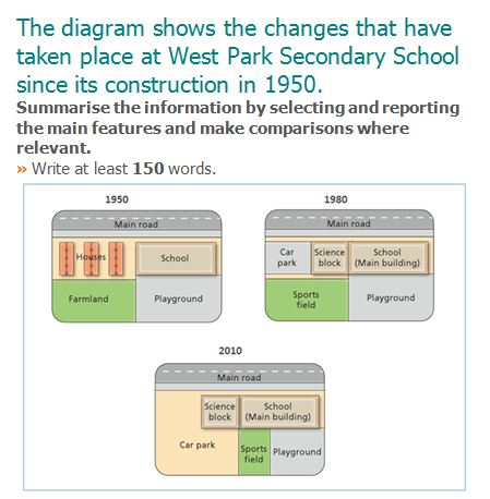
The given map illustrates the modifications that have been done to the west park secondary school since its construction in 1950.
Overview:
Overall, it is quite apparent that, the houses alongside the school had been replaced by car parking and science block and farmland had been changed to sports field.
Body Paragraph 1:
Moving on to the details, in 1950 there were houses alongside the school in the west direction. Moreover, the houses were replaced by car parking and new science block in the year 1980. There was a farmland to the south-west side of the school. In the year 1980, the farmland was changed to sports field. And in the year of 2010, the area of car parking had been increased, leaving less space for the sports field.
Body Paragraph 2:
Furthermore, the science block was same in 1980 and 2010. There was a playground to the south side of the school. The playground remained same in 1980 but in 2010, it was reduced to make more space for the sports field. The sports field in the 1980 had been shifted to the east-side. And there was a reduction in area to make more space for the car park.
Band 6.0 Sample: The diagram shows the changes that have taken place at West Park Secondary School since its construction in 1950.
Band 6.0 Sample: The charts below give information on the ages of the populations…